Wind Forecast Improvement Project (WFIP)
Wind power is a variable power source, dependent on weather conditions. Electric grid operators keep the grid stable by balancing the variable amount of power produced from wind farms by increasing or decreasing power production from conventional generation stations, including coal and natural gas. Having advance knowledge of when wind power will ramp up or down through accurate weather forecasts can lead to significant improvements in the efficiency of operation of these fossil fuel plants, as well as the entire electrical grid system, resulting in lower costs as well as lower CO2 emissions. Lowering the costs of integrating wind energy onto the grid will accelerate the development of wind energy as a growing component of the nation's energy portfolio.
Methods
Although NOAA already provides operational wind forecasts to the wind energy industry, this industry has made it clear that the current skill of these wind forecasts is deficient. WFIP is a DOE sponsored research project that aims to improve the skill of NOAA's short-term weather forecast models at predicting foundational weather parameters (for example, wind speed, turbulence intensity, and icing conditions) that impact wind energy generation. WFIP participants include several DOE and NOAA research laboratories, the National Weather Service, and partners from the private sector. The core elements of WFIP include:
- Deployment of a regional network of upper-air remote sensing observing systems
- Developing the capability to obtain and transfer to NOAA in real-time industry-provided meteorological observations from networks of tall towers and turbine nacelle anemometers
- Assimilation of the remote sensing, tall tower, and nacelle data sets into NOAA's developmental, rapid-update High Resolution Rapid Refresh (HRRR) numerical weather prediction model
- Dissemination of the HRRR model output to the wind energy industry, including WFIP private sector partners
- Forecasting wind power production (by DOE and private sector partners) based on HRRR output
- Evaluation of the economic benefit of the HRRR model, with and without assimilation of the new observations
Activities and Outcomes
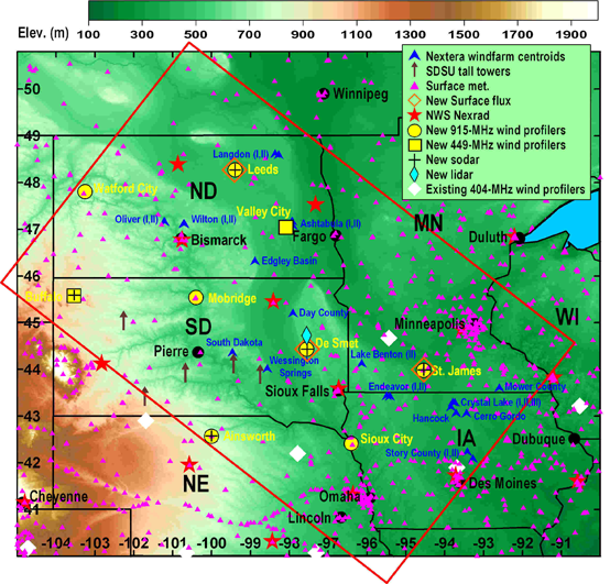
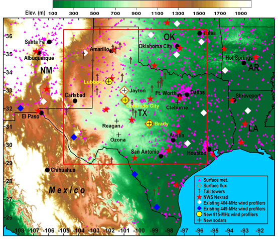
Two private sector groups were selected by DOE to partner with DOE and NOAA on WFIP, and therefore two geographic regions will be studied. The first private sector group is led by WindLogics, and will cover the northern Great Plains region. The second private sector group is led by AWS Truepower, and will cover an area of the southern Great Plains centered on west Texas. The instruments deployed in the two study areas are shown in the figures above. WFIP will span one full year of data collection, forecasting and economic evaluation, with an anticipated start date of July 2011. Links to public model evaluation web pages for the northern and southern study domains can be found at the top of this page.