High Resolution Climate Data from Research Ships
Project Summary
ESRL's Physical Sciences Laboratory (PSL) has developed a roving standard flux measuring system to be deployed on research vessels on an opportunistic basis and direct covariance air-sea flux measurements are performed on several oceanic cruises each year. This latter task promotes high-quality climate observations from UNOLS and NOAA research vessel fleet and from NOAA Flux Reference Buoys. Currently, climate data from 31 research vessels are archived at the Shipboard Automated Meteorological and Oceanographic Systems (SAMOS) at Florida State University. Flux Reference Bouy data are available at OceanSITES.
Because buoys and most ships and satellites rely on bulk methods to estimate fluxes, another aspect of this project is the use of direct measurements to improve the NOAA/COARE bulk flux algorithm — a state-of-the-art community resource. A full suite of direct, inertial-dissipation, and bulk turbulent fluxes of sensible heat, latent heat, and momentum are measured along with IR and solar radiative fluxes, precipitation, and associated bulk meteorological properties. This effort represents a partial transition of research from NOAA's climate research programs to operations under the Climate Observations Division (COD). To date, cruises have been conducted on four NOAA ships, nine UNOLS ships, four non-US ships, and one Coast Guard icebreaker to TAO buoys along the 95W and 110W, the PIRATA Northeast Extension (PNE), Indian Ocean RAMA, the Northwest Tropical Atlantic Station (NTAS) reference buoy, and the WHOI Hawaii Ocean Time Series Station (WHOTS) reference buoy.
Recent Results
Evaluation of Flux Reference Buoy Accuracy: 10 Years of Data
PSL deploys a roving flux standard aboard R/V's that service Ocean Reference Flux buoys. This meets 1) the need for a data quality assurance program to firmly establish that the observations meet the accuracy requirements, 2) the need for observations at high time resolution (about 1 minute) and, 3) the need to more efficiently utilize research vessels, including realizing their potential for the highest quality data and their potential to provide more direct and comprehensive observations. Over the last 10 years PSL has done deployments on the R/V servicing the WHOI buoy in the stratus region off Chile. An analysis of 3100 hrs of ship observations has been completed to evaluate the accuracy of the buoy observations.

- Related Information and Links
- Cruise Data
- Annual Reports
- Publications
- Working Group on Surface Fluxes
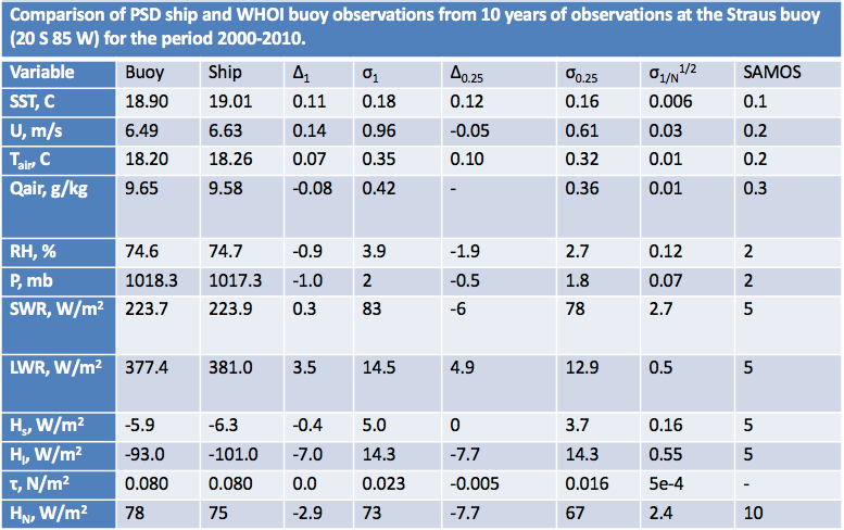
Table: Comparison of the ship and buoy platforms for all cases (N=939) when the ship was within 1 degree of the nominal buoy position and for 510 cases when the ship was within 0.25 degrees. The PSL mean wind, air temperature, and humidity were computed from PSL heights (zu_psd=17.7 m; zt_psd=15.5 m) to the same height as the buoy sensors (zu_buoy 3.3 m; zt_buoy=2.89 m) using the reference feature in the algorithm. Re-computation of buoy fluxes with COARE3.0 gives the same results as fluxes in the buoy flux file. From these results we can examine the mean bias (Δ) and 1-hrly standard deviation (σ), which will depend on the horizontal separation limits (we chose 1 degree and 0.25 degree). Note that the quantity σ /N1/2 gives an estimate of the sampling uncertainty of the mean bias, which are negligible because of the large sample size.