New radar retrieval technique may give forecasters a clearer picture of how much rain could fall during a storm

October 11, 2016

Cloud systems are a churning, complex mixture of interactions—the right combination of ingredients can quickly lead to dangerous conditions, such as flash floods. More accurate observations of these factors are important for improving forecasts and warnings. Christopher Williams, a CIRES researcher at ESRL's Physical Sciences Division, and colleagues from Colorado State University have developed a new radar retrieval technique that provides better estimates of the number and size of raindrops along with the strength of the surrounding updraft (or downdraft), which may give forecasters a clearer picture of how much rain could fall during a storm—and how fast the raindrops fall.
"By pointing two radars at the same volume of raindrops, this new retrieval technique simultaneously estimates raindrop populations and cloud dynamics," said Williams.
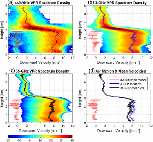
Vertically-pointing radars can observe raindrop Doppler motion—a combination of falling raindrops embedded in the moving atmosphere. Strong updrafts cause raindrops to ‘fall’ upwards, lifting them to colder heights, which promotes raindrop freezing and the formation of dangerous hail. When using only one vertically pointing radar, it is difficult to isolate raindrop motion from air motion. Interestingly, the 'apparent' size of raindrops is dependent on the radar operating frequency because the radar measured raindrop motion decreases as the radar frequency increases. Consequently, raindrops appear to fall slower when observed with higher frequency radars while the air motion is independent of radar frequency. Using this information, the researchers analyzed raindrop motion measured by two different frequency radars operating side-by-side during the Midlatitude Continental Convective Clouds Experiment to estimate raindrop population and air motion. Their findings are published in the October issue of IEEE Transactions on Geoscience and Remote Sensing.
"Improving weather forecast models is a cascading sequence," said Williams. "Improved radar rainfall retrievals will lead to improved understanding of cloud physics, which will lead to improved model parameters, which will eventually improve weather forecast models."
Contact
- Christopher Williams, lead author and PSL scientist, (303) 497-3829