Experiment studying major West Coast winter storms (Atmospheric Rivers) Kicks off this week in California

This week, as planes begin flying through storm clouds over the California coast, a ship set sail from Hawaii towards a destination in the northeastern Pacific. Their passengers aren’t commercial travelers or a pleasure cruisers, but the scientists and sensors involved in CalWater 2015, a two-month research study to investigate how West Coast rain and snow are impacted by atmospheric rivers (intense moisture-bearing winter storms) and aerosols (particles such as dust and pollution).
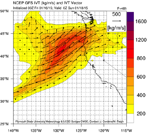
“Improving our understanding of atmospheric rivers will help us produce better forecasts of where they will hit and when, and how much rain and snow they will deliver,” says Allen White, a research meteorologist at NOAA’s Earth System Research Laboratories (ESRL) and CalWater 2015 mission scientist.
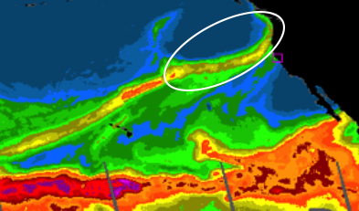
Atmospheric rivers (ARs) are narrow conveyor belts of water vapor in the atmosphere that can extend thousands of miles and are responsible for delivering much of the water vapor associated with major storms along the West Coast. In California, it's critical to understand if precipitation will arrive as snow–often good news, because it can 'store" water in slow-melting mountain snowpack–or rain, which can increase flood risk.
Continues White, “Better forecasts will give communities the environmental intelligence needed to respond to droughts and floods.”
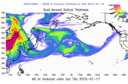
The other important piece of the study is aerosols. These particles can come from local sources or remote continents, and can directly influence western U.S. precipitation and how storms develop. When moisture from a landfalling AR is lofted by mountains, aerosols aloft can provide the "seeds", which can enhance precipitation.
Lead scientists from ESRL’s Physical Sciences Laboratory (including STC and CIRES researchers) and colleagues from the ESRL Chemical Sciences Laboratory (CSD) and other government agencies, university, and private industry will collect a variety of measurements from instruments aboard four research aircraft and a NOAA research ship, as well as land-based observations from NOAA Hydrometerology Testbed (HMT) field sites across California.
"It is rare that such an array of observing platforms are devoted to a field campaign," says White. "It’s both an exciting opportunity and a challenge to coordinate and make optimal use of these assets."
The combined air, ship, and land-based measurements will help researchers understand the scientific ingredients that contribute to atmospheric rivers. This information can be used to improve short- and long-term predictions of precipitation, and to develop decision support tools for extreme precipitation events, hazard response, and water supply for more effective water resource management.
In the air…
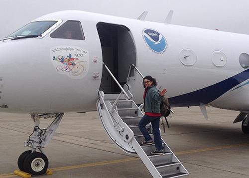
Flying out of McClellan Airfield in Sacramento, CA, NOAA’s P-3 and G-IV (aka Hurricane Hunters), and the DOE G-1 aircraft, and the NASA ER-2 out of Palmdale, CA will each carry specialized sensors to measure temperature, relative humidity, wind speed and direction, cloud properties, aerosol chemistry, ozone, and even ocean temperature, among other things.
In the ocean…
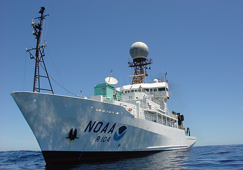
Leaving port on January 14th, the NOAA Research Vessel Ronald H. Brown began its trek from Hawaii to a targeted region off the California coast. Once there, the ship can be navigated within sight of any ARs in the region. Researchers aboard the Ron Brown will operate NOAA and DOE instruments, and release weather balloons and ozonesondes to study the interaction between the ocean and atmosphere and how it influences atmospheric rivers.
On the ground…
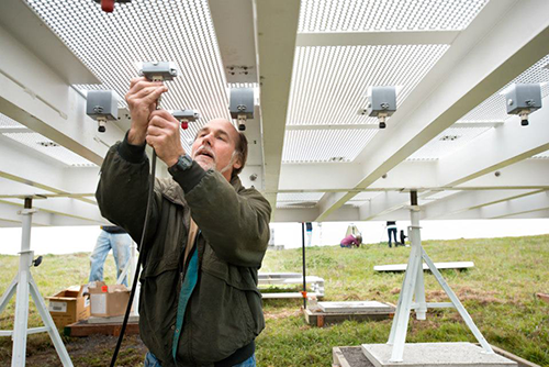
HMT has been monitoring atmospheric rivers for years at field sites across California, and for CalWater 2015 will contribute land-based measurements of precipitation, winds, snowpack, soil moisture, snow level, and surface weather. Also, the National Science Foundation is supporting the Scripps Institution of Oceanography and Colorado State University to install additional instrumentation at HMT’s Bodega Bay site to study aerosol chemistry.
Daily Forecast Briefings and Planning
Each morning, briefings are held to update investigators on current and forecasted weather conditions, atmospheric river development, and chemical and aerosol forecasts over the Pacific Ocean and West Coast.
These forecasts allow scientists to create flight plans for the NOAA G-IV and P-3 to measure an atmospheric rivers and guide DOE’s G-1 airborne aerosol and chemical measurements.
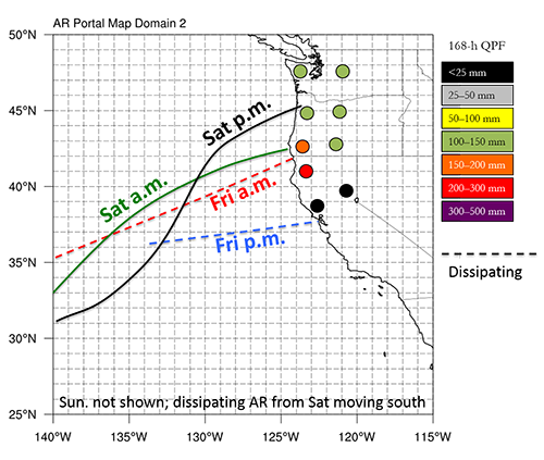
Sample Forecast Products:
- Related Links
- NOAA OAR Feature Story
- Scripps Press Release
First Flight Highlight...
"We performed our first science flight of CalWater 2015 on Thursday, January 15th with the NOAA G-IV flying across an atmospheric river that was making landfall on the Washington/Oregon coast.
This highly successful flight also marked an important milestone with the return of ozone measurements to the G-IV after almost 10 years. The ozone instrument was installed by the NOAA/ESRL Chemical Sciences Laboratory in partnership with ESRL's Physical Sciences Laboratory."
— Ryan Spackman, Flight Operations Scientist at NOAA/ESRL/PSL