Click image for more details
Contact: Andrea Ray
|
Pilot Project Provides Real-time Regional Climate Information to Missouri Basin Decisionmakers
February 16, 2012
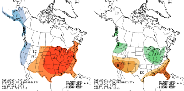
In response to La Niña-related risk of flooding in the Missiouri River Basin, scientists from ESRL's Physical Sciences Laboratory, NOAA's Central Region, and the National Climate Predictions and Projections Platform (NCPP) are providing climate information for a pilot project on the Missouri River Basin. As part of this project, monthly climate outlook webinars are being provided for federal, tribal, state and local governments, businesses, and the media. The next webinar is scheduled for Friday, 17 February 2012, and will be presented by Dr. Dennis Todey, State Climatologist for South Dakota, part of the pilot project team that crosses NOAA and its partners. These webinars allow producers and users of NOAA climate information an opportunity to talk directly with each other and discuss concerns and needs, including the short and long-term implications of forecasts and climate events. The webinars will be evaluated for their effectiveness and will evolve with feedback from participants.
In 2011 the Missouri River Basin experienced severe flooding due major shifts in typical wintertime weather patterns. These anomalies were associated with the tropical ocean phenomena known as La Niña, during which temperatures in the Tropical Pacific Ocean are cooler than average, and the effects on the atmosphere and climate can be felt around the world. In particular, La Niña can be associated with colder and wetter pattern in the northern Missouri River basin, and potential for spring and summer flooding downstream in the Basin. When the La Niña phenomenon returned in fall 2011, managers' concerns about flooding arose again, due to the impacts from the 2011 flooding.
The first webinar was in December 2011, prompted by the threat indicated by the seasonal climate outlooks. However, the conditions that might have lead to flooding have not developed as they did last year. The NWS Missouri Basin River Forecast Center says that "preliminary indications do not project the likelihood of significant widespread flooding this spring due to snowmelt alone." The webinars will continue at least through the snowmelt runoff season, and are expected to be a springboard into regular climate communcations from the NOAA Regional Climate Services Director, Doug Kluck, in collaboration with participants in this pilot.
Accessible regional climate information and products from NOAA can assist water managers and emergency responders in planning and early warning of potentially catastrophic extreme events. Lessons learned from this pilot will inform the development of future regional climate services.