ESRL Scientists Release East Pacific Climate Database
August 8, 2008
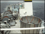
 NOAA S-Band Precipitation Profiler antenna dish inside its cylindrical clutter shield on the deck of the R/V New Horizon during EPIC 2001. |
The NOAA Earth System Research Laboratories's (ESRL) Physical Sciences Division has released two synthesis data sets containing observations of air-sea fluxes and cloud/radiative properties from nine years of cruises (1999-2007) in the Eastern Equatorial Pacific. The datasets are from Eastern Pacific Investigation of Climate (EPIC) Extended Monitoring cruises from fall 1999 through fall 2007. These observations were made as part a joint ESRL, NOAA Pacific Marine Environmental Laboratory (PMEL) and Woods Hole Oceanographic Institution (WHOI) climate monitoring project funded by the Climate Prediction for the Americas (CPPA) program in NOAA's Climate Program Office. The project includes instrument enhancements of the TAO buoys at the 95 W and 110 W lines (M. Cronin and N. Bond, PMEL) and ESRL's flux and cloud observations made during cruises to tend the TAO buoys and the WHOI climate reference buoy in the stratocumulus cloud region at 25 S 85 W. The equatorial database includes observations from 9 TAO-buoy tending cruises plus the EPIC2001 process study (which was held in the same region). The stratocumulus study contains data from annual cruises beginning in 2001. The Equatorial database is composed of time series of turbulent and radiative fluxes, low cloud properties, and column integrated water vapor and cloud liquid. The stratocumulus data have been further synthesized to simplify comparisons with climate models. Besides the basic time series, diurnal and daily averages have been computed and complete interpolated rawinsonde profiles are available.
EPIC was a joint NOAA-NSF program to study climate processes in the coupled ocean-atmosphere systems. EPIC included an intensive field program (EPIC2001) and an extended monitoring effort involving enhanced observations from TAO buoys and NOAA ships. In 2003 the spring TAO cruise was discontinued and an annual cruise to the WHOI buoy began. The EPIC monitoring observations have since undergone processing, quality control, and synthesis. The first step in the synthesis was to compile the combined files of the observations. The key to the ESRL role was direct observations of surface fluxes and cloud properties that can be used to provide context for the buoy annual time series.
Variability in the Eastern Pacific dominates weather and climate in the rest of the world through the El Niño – Southern Oscillation. The Eastern Pacific is also the breeding ground for many hurricanes that influence rainfall in the U.S. Southwest. Data collected from this mission will help understand and improve general model parameterizations, help develop satellite retrievals, and can be studied to help improve prediction of the North American Monsoon and sea surface temperatures in the Pacific and Atlantic oceans. These synthesis data are a key part of CPPA's VAMOS Ocean-Cloud-Atmosphere-Land Study (VOCALS), an international program designed to better understand the physical and chemical processes central to the climate system of the Southeastern Pacific.
| Contact: Chris Fairall | More Information: |