New Tool Could Provide 5-8 Hours of Lead Time for Precipitation Forecasts
January 16, 2008
 24 Hour Synoptic Precip. Map |
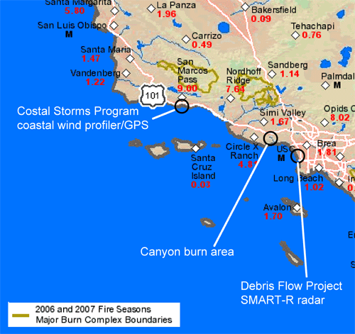
During the recent coastal storms in California, a new water vapor flux tool developed by NOAA's Earth Systems Research Laboratory provided the potential for 5-8 hours of lead time for forecasters to put out warnings for conditions that have been documented to cause significant mountain rainfall. The NOAA atmospheric river observatory near Santa Barbara, CA detected these precursor conditions that led to heavy precipitation in burn areas that are a risk for debris flows.
The water vapor flux tool uses winds measured along the coast at the altitude of the crest of the nearby coastal mountains and water vapor in the atmosphere that gets lifted by the mountains and condensed into rainfall. By combining the winds with the water vapor, the tool measures the horizontal transport, or flux of moisture, and correlates it with the observed mountain rainfall enhancement. This tool is being applied to three atmospheric river monitoring stations set up along the California coast by NOAA's Hydrometeorological Testbed and Coastal Storms Program. Atmospheric rivers are the regions of ocean storms where high winds and enhanced water vapor are concentrated. These factors combine to produce heavy rainfall upon landfall. Atmospheric rivers are visible in satellite images over the oceans, but their impact over land is not captured by NOAA's current operational observing system. Each atmospheric river monitoring station includes a Doppler wind profiler for measuring wind profiles and a Global Positioning System receiver for measuring the column-integrated water vapor concentration.
The location of the Coastal Storms Program atmospheric river monitoring station at the Santa Barbara Airport in Goleta, California, is well sited to help forecasters with flash flood forecasts for the many burn areas that scar southern California. At the same time, NOAA is partnering with the U.S. Geological Survey on a Flash Flood and Debris Flow Demonstration Project to gain a better understanding of the processes that lead to debris flows, especially in the burn areas. NOAA's National Severe Storms Laboratory has deployed a Shared Mobile Atmospheric and Teaching Radar (SMART-R) in Los Angeles to help monitor the local rainfall resulting from winter storms. The data from the SMART-R was heavily used by forecaster in Los Angeles and San Diego during the 2008 New Years storm that impacted most of California.
Results from the HMT and Coastal Storms Program will help the NWS Weather Forecast Offices and River Forecast Centers with extreme precipitation forecasts and flash-flood warnings, giving emergency managers more lead time to respond to hazardous weather and to protect the public. This research supports NOAA's mission goal of serving society's needs for weather and water information.
| Contact: Allen White |