
Measurements at the Mauna Loa Observatory stopped after the 2022 eruption of the Mauna Loa volcano, when lava flow crossed the access road and took out power lines to the facility. The observatory remains inaccessible by vehicle and without power from the local utility company.
Observatory staff has established limited solar power in four observatory buildings and restored approximately 33 percent of the measurements onsite, including the Global Monitoring Laboratory and Scripps critical CO2 records and other atmospheric measurements.
Media can contact: Theo Stein (303) 819-7409 (theo.stein@noaa.gov) or Karin Vergoth 303-632-6413 (karin.vergoth@noaa.gov)
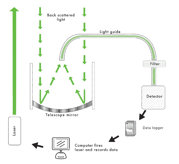
Lidar (LIght Detection And
Ranging), is often refered to as laser radar. Light transmitted by a laser is scattered by atmospheric
consituents and detected by an optical telescope. The properties of the incoming light enable certain properties of the
targets to be determined, and timing of the measurement determines the altitude of the targets.
The National Oceanic and Atmospheric Administration (NOAA) Earth System Research Laboratory (ESRL), Global Monitoring Laboratory (GMD) operates Lidar at four locations.
At Mauna Loa, Boulder, and Samoa, the Lidars are part of the Network for the Detection of Atmospheric Composition Change (NDACC). At Trinidad Head the Lidar is part of the NASA Micro-pulse lidar network (MPLNET).
CLidar (Camera Lidar), is an innovative on the standard lidar developed at the ESRL Mauna Loa Observatory to measure boundary layer aerosols. Clidar uses a charge-coupled device (CCD) camera to image the entire laser beam from a few hundered meters away.