The latest official seasonal forecast was issued by the NWS/Climate Prediction Center last week. This page reproduces the maps discussed and provides active links to CPC pages. The these and other outlook maps are accessible from the CPC main page, look down to "outlooks" and click on your preferred time scale, or access it from "index" on the next line. I find the color maps are easiest to read, and these are accessed from clicking on "monthly and seasonal". You can also look at black and white versions by choosing either "U.S. monthly temp and ppt outlooks" (September), or "US seasonal" (Sept-Oct-Nov avg) . The official seasonal forecasts are issued on Thursdays in the middle of the month; the next one will be October 12th. Schedule for future outlooks.
September and Sept-November forecast
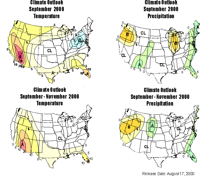
The climate outlook for precipitation for September (above) is for a slightly increased probability that the total precipitation for September in the central and eastern part of Colorado (including the the headwaters basin area) will be in the *wettest* third of the Septembers in years used for comparision, 1961-1990. Two points to clarify: all the comparisons are made to a "base period" of 1961-1990; and to clarify how the "terciles" work, you could divide all years into the wettest third (upper tercile), middle third, and lower third (lower tercile). By chance, there's a 33% risk that any given year would fall in each of these terciles. This year, for the region of the Colorado Rockies and most of the San Juan basin, the risk increases to between 33-38% that the accummulated ppt in September will be in the wettest third (upper tercile). The eastern plains of Colorado are included in the region with a slightly increased risk for upper tercile precipitation.
The climate outlook for temperature in September shows that the western third of Colorado has an increased probability (33-38%) that temperatures will be in the warmest third (upper tercile), and this risk increases for states to the south and west to a 30% increased risk, or 63% chance of upper tercile precipitation in the area where California, Nevada, and Arizona come together.
For 3 month season from September through November, the probability is also increased for precipitation in the upper tercile. Note that this is for the *average* of those three months. In the same period there is an probability for above normal temperatures in the northwest quarter of the state.
Long-Lead forecast
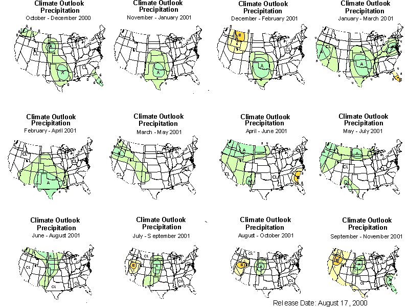
With regard to the winter season, the long-lead outlooks for precipitation (above)for 3-month overlapping seasons at show no anomaly forecasts for the west slope of colorado for the winter, but the there is an increased risk that the east slope will be in the wettest tercile. However, later in the winter, ion the Febrary-March-April and march-april-May 2001 seasons, there is an enhanced probability that the west slope will be in the upper (wettest) tercile, compare to those seasons in 1961 to 1991. Individual seasons can be viewed by clicking on the season you want from at this index. You can also read the technical long lead prognostic discussion .
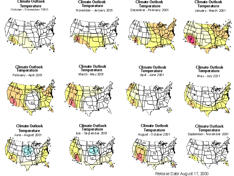
A note on the long-lead temperature outlooks (above) for the winter: the outlook for much of the US is for warmer than average conditions, but keep in mind that the last three winters have been among the warmest on average. So, although the upcoming winter is expected to be warm, it is likely to be somewhat cooler in many places than the winters in our recent memory (see the prognostic discussion of the long lead forecast, for a technical discussion)
Please feel free to contact me if you have futher questions, andrea.ray@noaa.gov, 303-497-6434. To see my description of last month's forecast, see below.
We are planning to give a more complete discussion and briefing on the winter forecasts after a meeting of the SWAT team in October, starting our briefing after the SWAT meeting. Tentatively we are thinking of the afternoon of thursday, 19 October and perhaps extending onto Friday. Denver might be the most convenient place for everyone, but its open to discussion. I'll send a separate message on this later, or feel free to contact me about that or if you have suggestions on what you'd like to hear in that briefing.
The latest official seasonal forecast was issued by the NWS/Climate Prediction Center yesterday. It is accessible on the web from the CPC main page, look down to "outlooks" and click on your preferred time scale, or access it from index" on the next line, then choose either "U.S. monthly temp and ppt outlooks" (August), or "US seasonal" (Aug-Oct avg). I find the color maps are easier to read, and these are accessed from clicking on"monthly and seasonal". The official seasonal forecasts are issued on Thursdays in the middle of the month; the next one will be August 14th.
The forecast for August is for a increased risk that the total ppt for August will be in the *wettest* third of years for the headwaters basin area. Just to clarify, you could divide all years into the wettest third (upper tercile), middle third, and lower third (lower tercile). By chance, there's a 33% risk that any given year would fall in each of these terciles. This year, for the region we are interested in, the risk increases to 38-43% that the accummulated ppt in August will be not just above average but in the wettest third (upper tercile). For the 4 corners are and parts of AZ and NM, the risk is increased 10%, or a 43% chance of ppt in the upper tercile.
By the way, 10% increased risk may not seem like much, but it actually represents a fairly substantial increase as forecasts for precipitation go. The risk is also increased for ppt in the upper tercile for the 3 month season from August-October.
Regarding the monsoon specifically, the CPC monthly prognostic discussion states that, "the monsoon started early this year and is expected to be wetter than normal overall due to strong middle troposphere subtropical ridge development and low-level heat low formation resulting from increased surface warming - which are in turn at least partly due to the lack of snow pack over the mountains during the previous la nina-influenced winter." To see the full discussion, click on "prognostic discussion" from either either "U.S. monthly" (august) , "US seasonal" (Aug-Oct avg), but not from the color figure.
So we're all waiting for the monsoon to make its way north to us, and the NWS seasonal forecasts are that it will eventually get here and be a decent rainy August. this is also consistent with some research that finds that the summers after La Nina winters tend to have stronger monsoons.
*Note: as of 22 February, this file has been edited to correct several typos and to add the URL of this site; however none of the information has been changed.