Monthly Climate Timeseries:
Pacific Meridional Mode (PMM) SST Index
- Description:
- The mode describes the meridional variability in the tropical Pacific Ocean. A similar mode but for the Atlantic is available.
- Image:
-
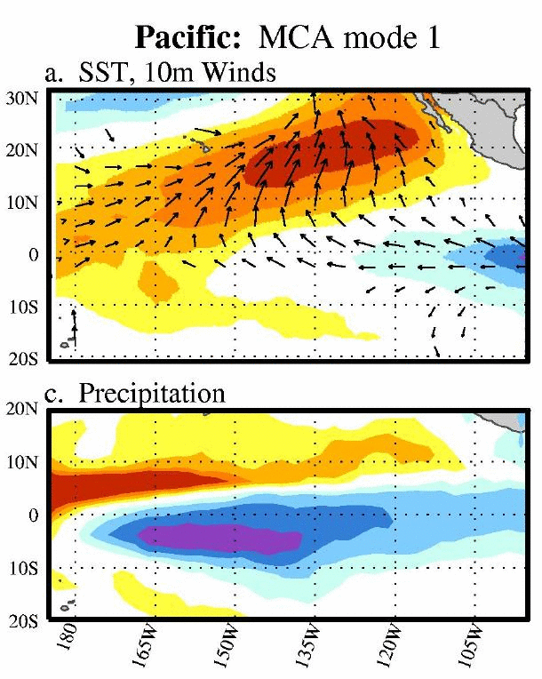
From Chiang and Vimont (2004): Spatial properties of the leading MCA mode 1 in the Pacific. (top) Regression maps of the MCA leading mode SST normalized expansion coefficients on SST and 10-m wind vectors. Wind vectors are plotted where the geometric sum of their correlation coefficients exceeds 0.27 (the 95% confidence level). (bottom) Same as (a), (b) but for precipitation (mm day21). In general, shaded regions in all panels exceed the 95% confidence level.
- Timeseries Plot:
- Select this link to get a plot. Plot is taken from the Times-series Plotting and Analysis web-page.
- Calculation Method:
- The PMM spatial pattern is defined via applying Maximum Covariance Analysis (MCA) to sea surface temperature (SST; left field) and the zonal and meridional components of the 10m wind field (right field) over the time period 1950-2005, from the NCEP/NCAR Reanalysis. To define the spatial pattern, data are defined over the region (21S-32N, 74W-15E), and spatially smoothed (three longitude by two latitude points). The seasonal cycle is removed, data are detrended, a three-month running mean is applied to the data, and the linear fit to the Cold Tongue Index (a measure of ENSO variability) is subtracted from each spatial point. Spatial patterns are defined as the first left (SST) and right (winds) maps resulting from singular value decomposition of the covariance matrix between the two fields. The PMM time series below is calculated via projecting SST or the 10m wind field (detrended, CTI removed, but no 3-month running mean) onto the spatial structure resulting from the MCA above.
- Time Interval: Monthly
- Time Coverage: 1948 to present
- Update Status: Monthly
- Get Data:
- Update Status: Monthly
-
PMM (SST): Standard PSL Format (What is standard format?)
PMM (Wind): Standard PSL Format (What is standard format?)
- Source:
- Data is from U Wisconsin using the NCEP SST
- References:
-
- 2004 Chiang, J. C. H., and D. J. Vimont: Analogous meridional modes of atmosphere-ocean variability in the tropical Atlantic and tropical Pacific. J. Climate,17(21), 4143-4158.