Forest Fire Effects Observed at Southern Great Plains Site
The U.S. Department of Energy Atmospheric Radiation Measurement (ARM) program established the Southern Great Plains (SGP) Cloud and Radiation Testbed (CART) site in 1992 as the first of its field measurement sites. The CART site covers an area of ~142,000 square kilometers in north-central Oklahoma and south-central Kansas, and was designed to conduct measurements of radiation, cloud, and aerosol properties over a region similar in size to a satellite viewing area. It was chosen to represent a typical rural, mid-continental site, where satellite retrievals of atmospheric parameters are complicated by land use patterns. It is distant from any large urban areas, so that the atmospheric aerosols over the site can often be interpreted as representative of mixed regional aerosols.
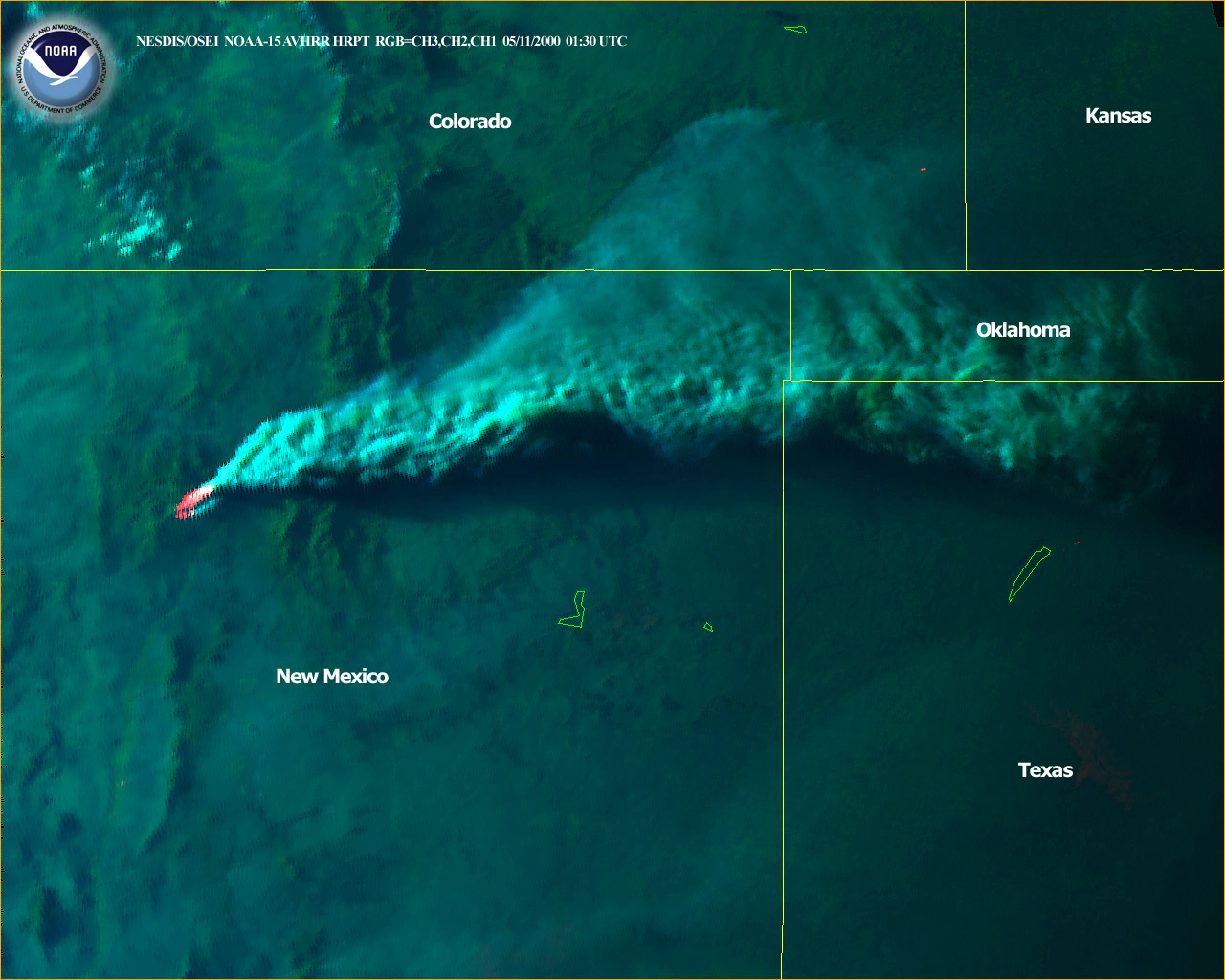
The Aerosol Observing System (AOS) at the DOE/ARM Southern Great Plains CART site began to detect increased aerosol levels possibly due to the New Mexico forest fire as early as 6:00 PM UTC on 10 May 2000. Smoke from this fire is being transported eastward and reaching the ARM SGP site in Lamont, Oklahoma where the Climate Monitoring and Diagnostics Laboratory aerosol group conducts both surface and aircraft measurements.
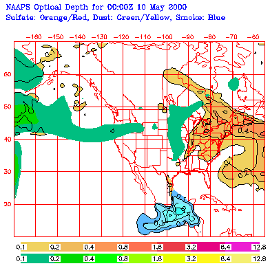
(provided by NAAPS)
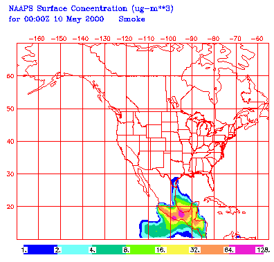
(Provided by NAAPS)
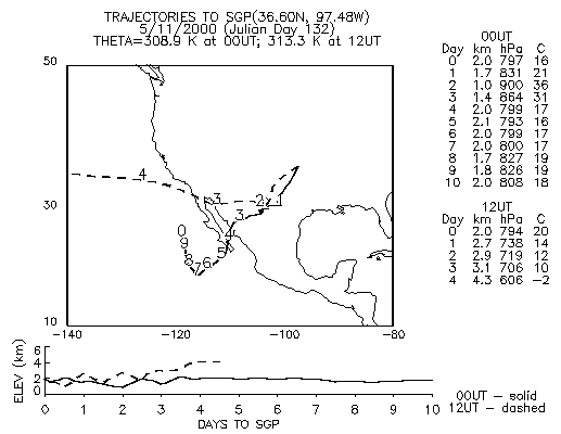
The figure to the left is a back isentropic trajectory arriving at the Southern Great Plains site at 2 km elevation on May 11, 2000. The numerals along the track indicate the number of days back along the trajectory. The solid line corresponds to arrival at 00 GMT; the dashed line to 12 GMT. The lower plot tracks the vertical motion along the trajectories. (postscript file provided by ESRL)
Trajectories arriving at several levels in the atmosphere above the Southern Great Plains site indicate the possibility of multiple sources for the aerosol measured there. Trajectories at the lower levels indicate origins to the south, possibly in Mexico, while at 2 km trajectories indicate a possible origin in New Mexico.
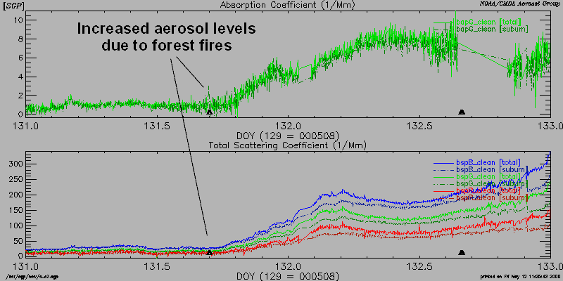
AOS surface aerosol data for the period 5/10/2000, 0000 UTC - 5/12/2000, 0000 UTC. The figure below shows aerosol light absorption coefficient (BapG, upper panel) and aerosol light scattering coefficients at 450, 550, and 700 nm (blue, green, and red traces, lower panel) plotted against day of the year. Smoke aerosol began to be detected around 1800 UTC, or 1300 CST on 5/10/2000. Peak light absorption and light scattering coefficients during the smoke episode were factors of ~8 and ~12, respectively, higher than the typical values observed earlier that day. Aerosol levels appear to be increasing leading up to 0000 UTC on May 12th, and reach a maximum value of nearly 250 Mm-1 (green channel). The broad event peak is indicative of an aged, well mixed aerosol from a distant source.
(EPS file provided by ESRL)
The SGP AOS has been operational since July 1996, but significant system changes were made in early 1997 (when Dr. John Ogren of the ESRL Global Monitoring Division became AOS Instrument Mentor) that permitted the determination of additional aerosol properties. The extent to which surface aerosol measurements represent the overlying atmospheric column is not well understood. Surface sites have the advantage of being able to be run continuously, and can show long-term trends and seasonal cycles in aerosol properties.
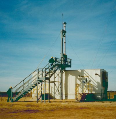
The AOS is housed in a fixed-location, temperature-controlled trailer (location: 36° 36' 19.6'' N, 97° 29' 20.7'' W, 315 m above sea level) at the CART site. Because of agricultural activities near the site, sampling of the ambient aerosol is conducted at the top of an intake stack (~21.6 cm inner diameter) at a height of ~10 m above ground level.