2016 News & Events
North Dakota's Bakken oil and gas field leaking 275,000 tons of methane per year
11 May 2016
adapted from the story by CIRES Communications
The Bakken oil and gas field is leaking a lot of methane, but less than some satellites report, and less than the latest Environmental Protection Agency inventory for petroleum systems, according to the researchers' calculations. That's the finding of the first field study measuring emissions of this potent greenhouse gas from the Bakken, which spans parts of North Dakota and Montana. "Quantifying atmospheric methane emissions from oil and natural gas production in the Bakken shale region of North Dakota" was published today in the Journal of Geophysical Research: Atmospheres.
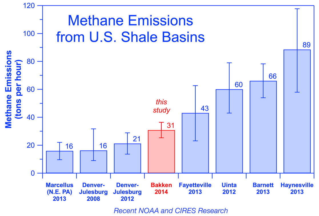
Researchers found that 275,000 tons of methane leak from the Bakken each year, similar to the emission rate found for Colorado's Denver-Julesburg Basin, another oil-producing region.
"This study provides a key snapshot of Bakken methane emissions that will help answer the bigger questions: how much methane is the U.S. emitting, where is it coming from, and how is that changing over time?" said Jeff Peischl, the study's lead author and a scientist from the Cooperative Institute for Research in Environmental Sciences (CIRES) at the University of Colorado Boulder working at CSD. Co-authors include scientists from NOAA, the University of Michigan, Stanford University, and the University of California, Davis.
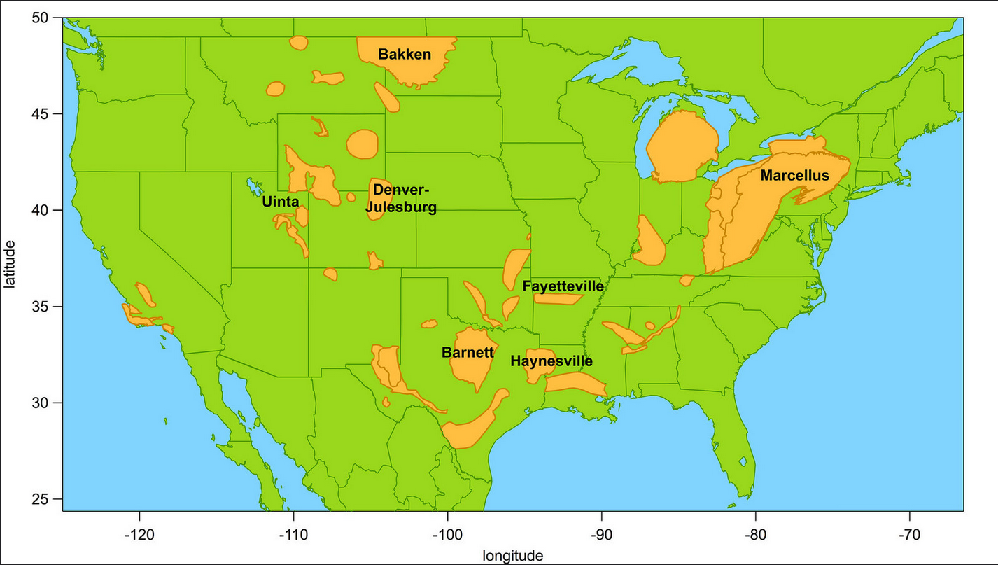
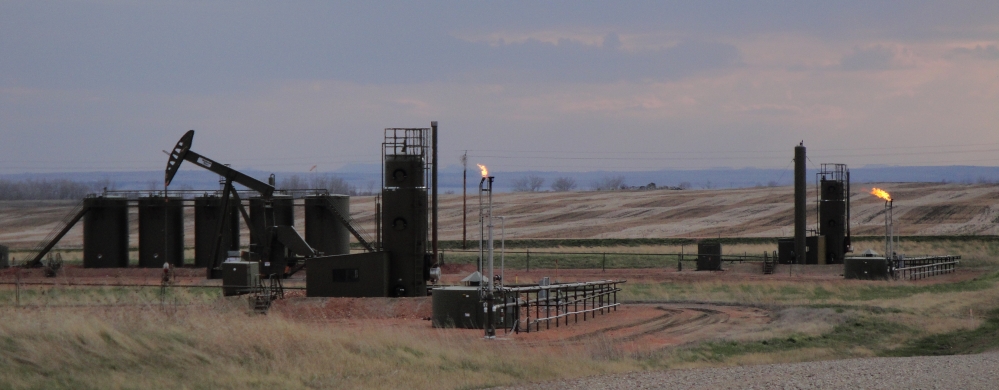
The 200,000 square-mile Bakken Shale formation is one of the country's top oil-producing regions. At the time of the study in May 2014, the Bakken accounted for 12.5 percent of all crude oil produced in the United States. Only Texas surpasses North Dakota for oil production among states.
Methane is the primary component of natural gas and the second-most common greenhouse gas emitted by human activity in the U.S. Some methane is produced by natural sources such as wetlands, but livestock feedlots, landfills, coal mines, and oil and gas production also add significant amounts of methane to the atmosphere. Pound for pound, methane is significantly more efficient than carbon dioxide at trapping heat in the atmosphere over a 100-year period. Eventually, atmospheric methane reacts to form to carbon dioxide, the most common greenhouse gas, which persists in the atmosphere for thousands of years.
During Twin Otter Projects Defining Oil/gas Well emissioNs (TOPDOWN), researchers flew an instrumented NOAA Twin Otter aircraft upwind and downwind of production facilities in the Bakken, and calculated the region's total methane emissions using a technique called mass balance. The researchers evaluated the chemical composition of the air samples to determine if the methane captured during the flights came from oil and gas operations or other activities, such as livestock feedlots. The majority came from oil and gas, they found.
This study is one of several that are part of an ongoing effort to understand the atmospheric impact of oil and gas drilling across the United States, an effort that has revealed major differences in emission rates among regions and types of oil and gas basins.
The Bakken's 2014 methane emission rate of 275,000 tons per year is significantly less than estimates generated by satellites for the region between 2006 and 2011. The researchers also compared the measured emission rate for the Bakken to EPA's 2013 national inventory, the latest year available when the paper was submitted. EPA only reports total national greenhouse gas emissions from petroleum systems, so researchers calculated the Bakken’s share of the EPA inventoried emissions based on the Bakken’s oil production level.
Another recent study showed the Bakken leaks ethane, also a component of natural gas, at a rate of about 250,000 tons per year, enough to be detected by atmospheric monitors in Europe.
"Policymakers need good data to make good decisions," said Tom Ryerson, study co-author and NOAA scientist. "As we transition from coal to natural gas and other sources of energy, it's important that we understand the climate impacts of the fuel choices we're making."
This study is part of a continuing NOAA effort to understand methane emissions from all the major sources in the U.S. and across the globe. This larger effort involves tracking the natural emissions from tropical wetlands and sources in the Arctic, as well as human-caused emissions from landfills, agriculture and animal husbandry, and energy production and use.
J. Peischl, A. Karion, C. Sweeney, E. A. Kort, M. L. Smith, A. R. Brandt, T. Yeskoo, K. C. Aikin, S. A. Conley, A. Gvakharia, M. Trainer, S. Wolter, and T. B. Ryerson, Quantifying atmospheric methane emissions from oil and natural gas production in the Bakken shale region of North Dakota, Journal of Geophysical Research: Atmospheres, doi:10.1002/2015JD024631, 2016.
Abstract
We present in situ airborne measurements of methane (CH4) and ethane (C2H6) taken aboard a NOAA DHC-6 Twin Otter research aircraft in May 2014 over the Williston Basin in northwestern North Dakota, a region of rapidly growing oil and natural gas production. The Williston Basin is best known for the Bakken shale formation, from which a significant increase in oil and gas extraction has occurred since 2009. We derive a CH4 emission rate from this region using airborne data by calculating the CH4 enhancement flux through the planetary boundary layer downwind of the region. We calculate CH4 emissions of (36 ± 13), (27 ± 13), (27 ± 12), (27 ± 12), and (25 ± 10) x 103 kg/hr from five transects on three days in May 2014 downwind of the Bakken shale region of North Dakota. The average emission, (28 ± 5) x 103 kg/hr, extrapolates to 0.25 ± 0.05 Tg/yr, which is significantly lower than a previous estimate of CH4 emissions from northwestern North Dakota and southeastern Saskatchewan using satellite remote sensing data. We attribute the majority of CH4 emissions in the region to oil and gas operations in the Bakken based on the similarity between atmospheric C2H6 to CH4 enhancement ratios and the composition of raw natural gas withdrawn from the region.